
Subdivision Process
Onondaga County Guide to the Subdivision Process
Please follow the complete guide to ensure that you take the proper steps necessary to subdivide your property. – download HERE.
1. Local Municipality
The first step in determining whether or not your proposed plans are likely to be approved is to see your local municipality’s development authority. Contact your Village, Town or City government and ask them to review your preliminary sketch.
Signatures Required :
In a town : Signature of the town supervisor or planning board chair
In a village: Signature of the village mayor or planning board chair
In the City of Syracuse: Required signatures include:
- City Planning Commission Secretary – Contact City Zoning Office, City Hall Commons, 201 E. Washington St., call (315) 448-8640. (After the map is filed, the applicant must call the City Zoning Office with the filing date and map number)
- City Engineer – Contact the Deputy Commissioner of Public Works Technical Services, Room 401 City Hall, call (315) 448-8200.
- City Assessor – Room 130 City Hall; call (315) 448-8280.
2. Onondaga County Health Department, Bureau of Public Health Engineering review
The Onondaga County Health Department – Bureau of Public Health Engineering is required to review and stamp all filed subdivision maps regardless of the size or type of the project.
Please find complete instructions HERE.
Contact the Bureau of Public Health Engineering:
Civic Center, 12th Floor
421 Montgomery St.
(315) 435-6600
PHESubdivision@ongov.net
3. Department of Transportation Review
Any subdivisions with frontage on a public road should contact the road owner(s) to review your subdivision plans, prior to local approval. Applicants are encouraged to contact road owners as early in
the planning process as possible to review plans for sight distance or other safety concerns. Be sure to contact DOTs before you purchase your final design plans that include houses, driveways, or septic system locations.
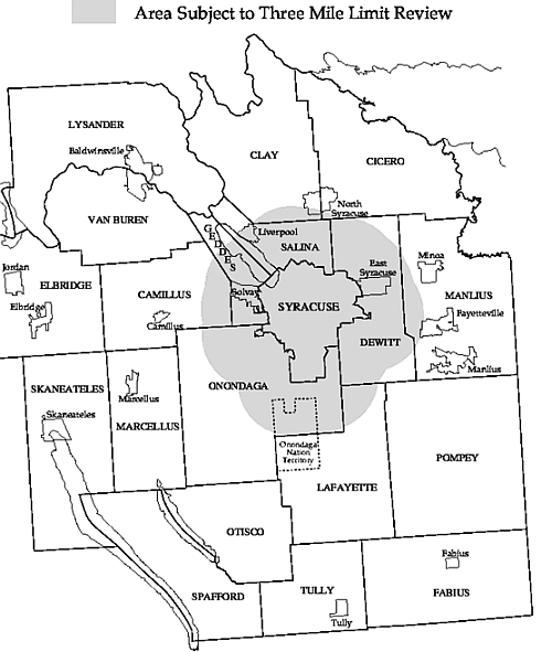
4. City of Syracuse Three Mile Limit Review
Subdivisions occurring within three miles of Syracuse are subject to extra-territorial review by the City of Syracuse (Ch. 370, NYS Laws of 1913, Ch. 447, NYS Laws of 1920), to ensure orderly development.
5. Right-of-way Designation (“Street Name”) Law Review
This step is required to ensure compliance with the County’s Right-of-Way (ROW) Designation Law (#5-
1972), to ensure proper nomenclature is used to identify existing and proposed rights-of-way, such as
street names, on ALL filed subdivision maps.
A letter of compliance is issued by the Onondaga County Department of Planning – GIS/Addressing
Division. This letter is required for subdivision filing with the County Clerk. Applicants are instructed to
email a digital copy of your subdivision map to the Planning Department for a ROW Designation
Compliance Review, or call the Department to discuss alternate submission of plans.
6. Certification of Real Property Tax Status
- If the subdivision is outside of the City of Syracuse, a private abstract/title company must provide certification that all real property taxes have been paid. Some companies have offices in the County Clerk’s Office, on the second floor of the Onondaga County Court House. Any private abstract/title company can provide the certification.
- If the subdivision is in the City of Syracuse, the City Finance Department will provide the certification. Contact Room 110 City Hall, call 448-8300.
7. File your map at the Onondaga County Court House
This is the final step in the subdivision process. Approved subdivision maps are to be filed with the County Clerk, Room 200, Onondaga County Court House, 401 Montgomery St., Syracuse. The filing fee is $10.00. For more information call 435-2226/2227.
Subdivision Map Requirements
A. The subdivision map must be:
- Printed in black ink on either linen, cloth backed paper, or Mylar.
- No larger than thirty-six by forty-four inches (36”x 44”).
- Clear and legible for reproduction. (No folded or bent maps).
- Signed in black ink by all required officials. Only original signatures are acceptable.
- All stamps must be in black ink.
B . The subdivision map must include the following information:
- Tract name (cannot be Farm Lot or Military Lot)
- Property location by town, city or village
- Farm/Military Lot and/or block numbers
- North arrow
- Certificate of Licensed Land Surveyor: “We (or I) hereby certify that this is an accurate subdivision plat prepared by us (or me) on (date). This subdivision plat meets the current standards stated in the NYSAPLS Code of Practice for Land Surveys pertaining to All Boundary/Title Surveys. The subdivision boundary closure is (boundary closure precision). This map is not valid without the original seal of the surveyor.”
C. Onondaga County subdivision map standards required for filing:
- Each new lot will have a definite designation number or letter per the new map.
- Each amended lot will have a definite designation per the new map to avoid confusion with the original lot designation as shown on a previous subdivision map (e.g. Lot 10 becomes Lot 10A).
- Existing parcels or lots to be added to or subtracted from will have a definite designation per the new map depicting all necessary conveyances.
- Each line or curve of all new or amended lots must clearly show all necessary geometry.
- Shorelines will have a tie line with geometry for closure.
- The map shall have absolutely no disclaimers preventing the use of said map as a legal descriptor for any new or amended lot or lots shown.
- All amended maps or resubdivision maps must recite which existing map # they are amending & clearly describe which lots or areas are being amended & why.
Please follow the complete guide to ensure that you take the proper steps necessary to subdivide your property. – download HERE.